
History of Frankley, in Bromsgrove and Worcestershire
Frankley, a Parish in Worcestershire, has a rich history that dates to the 1086 Domesday Survey. The name Frankley derives from the Old English Francalēah, meaning ‘Franca’s wood/clearing’.
The ancient hamlet centres on Church Hill around the junction of Scotland Lane and Frankley Lane and still nestles in countryside.
The area, historically known for its green belt, was a site of common grazing in the medieval period. Much of the manor lies on the high hilly ground of the Sedgley-Northfield Ridge and fine views can be had from Frankley Hill and Frankley Beeches. It is possible on a clear day to see from here the mountains of the Berwyn Range above Llangollen in north-east Wales some 70 miles away.

Frankley’s entry in the Domesday Book from Domesday Online
Franchelie: first record in the Domesday Book 1086
The first known underlord of the manor of Frankley was Bernard de Frankley in 1166. The title of the manor passed to Thomas Lyttelton, who proved his descent to the manor, and the title remains in the family to this day with Viscount Cobham of Hagley Hall in a descent. It is very likely that he was descended from one of the followers of William the Conqueror in 1066 and took his name from the manor. Frankley was passed down through his family, sometimes in the female line (whence the surname Lyttleton) until 1299 when the title was sold.
The Parish has a notable history, including the Manor of Frankley in the fourteenth century,
owned by Adam de Harvington, Lord Treasurer of Ireland.

It is said that Judge Lyttelton of Frankley, who died here in 1481, was responsible for the digging of Westminster Pool. It is allegedly so-called because the area of the pool was the same as that of Westminster Hall in London. This may well have been located alongside Westminster Farm just to north of the Church of St Leonard.
Judge Sir Thomas de Lyttleton; c1407– 1481 – image from Wikipedia
Frankley Hall stood from at least 1601 west of St Leonard’s Church. At that date it was referred to in parliamentary papers as ‘a very fair brick house and in good repair [with] large and sufficient barns, stables, and outhouses.’
Frankley Hall stood from at least 1601 west of St Leonard’s Church. At that date it was referred to in parliamentary papers as ‘a very fair brick house and in good repair [with] large and sufficient barns, stables, and outhouses.’

It replaced an earlier building part of whose medieval moat is still filled with water. Burned by the Royalists under Prince Rupert during the Civil War on 17 May 1645 to prevent its use as a Parliamentary garrison, its dressed stones was later used to build the church tower.
The remains of the moat of Frankley Hall
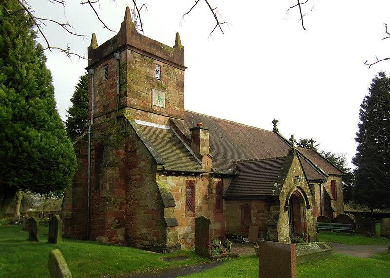
St Leonard’s Church
The 15th century church building lies to the north of the village, constructed from sandstone in
red and grey colours until 1965. In 1738 the church was granted permission to bury parishioners here in the churchyard, rather than be taken to the mother church for interment. St Leonard’s became a parish in its own right in 1866.
A new church hall was constructed in 2005.

St Leonard’s Church. Thanks to Local History Digital Archive of the
History Department of King Edward VI Grammar School, Five Ways, Bartley Green

Frankley Reservoir was built between 1896 and 1906 to bring water from Wales.
An ambitious project to bring water to the ever-expanding town of Birmingham 75 miles from the Elan Valley in mid-Wales began 1874. Water was brought via by two pipelines over one metre in diameter and entirely gravity-fed at an average gradient of 1:2300 (about 4.5%) – there is a drop of only 52 metres along the whole pipeline. The project was opened 1904 by King Edward VII. Within the year some twelve million gallons were being piped annually to Frankley Reservoir which still provides for most of Birmingham’s needs.

Frankley Beeches is a prominent landmark at the north end of Egghill Lane, now in the care of the National Trust. Land here was given by George Cadbury as parkland to the City and rises to 795 feet, c240m. Beeches are large distinctive trees which live to a great age. A stand of such trees is always a prominent landmark. James Sherriff’s 1798 map of 25 miles around Birmingham also shows Frankley Ashes located in the Frankley Hill area.
Frankley also gave its name to Frankley services, a motorway service area on the M5 motorway to the northwest of the village, which opened with the motorway in 1966.
In 2026, the village has a population of 122 residents.


